|
|
|
|
2 June Well we should have been out with the Ramblers around Monsal Head but we got to the car park too late. I drove like the proverbial to Uttoxeter and then Ashbourne but didn't catch them. I hadn't got a map with me (actually I had both Brecon Beacons maps but hey weren't a lot of good) so we just wlaked up Dovedale to Milldale and back climbing Thorp Cloud on the way. A long drive for not such
a long walk. It was nevertheless very enjoyable with slightly different views. I
was of course peak-bagging which adds an extra dimension to the enjoyment. My
objective was Y Garn. Not the big one - the three thousander footer in the
Glyders – but the outlier to the Rhinogs. It just tops two thousand foot and
is also a Marilyn. I parked at Ganllwyd on the Dolgellau-Trawsfynydd road. I
can’t remember ever going up there before. As ever I was trying to follow the
Nuttalls’ route but this wasn’t easy in the Coed Brenin forest at the
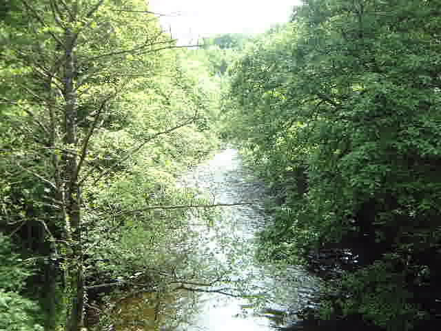
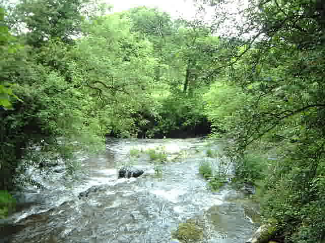
beginning. The path sets off up the Gamlan river and takes in Rhaeadr Du (The
Black Falls) which have a drop of 60-odd foot. They take their name from the
slab of black rock over which they fall. Pause for photos. It was just after the falls that I lost the route. The
Nuttalls say follow the National Trust waymarks but the book is getting quite
old (10 years plus) and the signs
looked quite new. When they started going in the wrong direction, I suspected
that this was a new tourist path through the woods and I went the other way over
the wall. This was wrong but turned out to be a short cut to the right place ie
the track running just in from the edge of the woodland. A word in praise of the woods. Lovely broad-leafed trees,
certainly in the section nearest the road and the waterfalls. And with pleasant
sunshine bursting through. Much better than these nasty conifers – it’s just
a shame that they are more successful commercially – the grey squirrels of the
woodlands world. It’s a steady uphill pull in the woods but the paths are
good. Once you leave the woods and get past the ruins of the gold mine, the
paths all disappear and the gradient gets steeper. It’s hard work as you pick
your way through gaps in the heather, which are usually pretty damp, working
your way up the south east ridge. There are no gates in the walls but I found a
gap in the first one and then worked my way across to another gap below a
valley. This looked to be the best way of skirting around south of the cliffs
below Y Garn. There was a bit of a path beside the stream for a while
but when the grass turned to heather again I turned left and climbed out of the
valley. This brought me to a wall – a very solid looking wall which just had
to be climbed over. Then I worked my way along the wall its junction with
another which I followed for a little while and then climbed over. I was now on the open land surrounding the summit. There
was lots of horizontal rock which typifies the Rhinogs. It was still rough going
picking my way as best I could and there were lots of false summits along the
way. But there was one super point where you emerge and see for the first time
the ridge of the Rhinogs proper. The sunshine had gone by this point so they
looked positively Saturnine in the gloom. Not much more to go to the true top which has a bit of
rock and a large, pointy cairn. I stopped, had a drink, read up the Nuttalls’
description again and savoured the view. I’ve been picking off these Bala/Dolgellau
peaks a lot of late and it’s wonderful how they are all a bit different. This
is the best view I’ve had of the Rhinogs. Cader Idris was pretty good too as
it showed the great cliffs below the summit. It was a good view of the Cyfrwy
Arrete too. The route down was along the north side of the cliffs. It was back to the continuation of the first solid wall that I’d climbed. That was pretty tricky and then to the left of the wall leading away from it. There is a path - often fairly indistinct – all the way. After a while it plunges sharply and it’s fairly slow going as you pick you way down. Towards the bottom there’s a wall across but there is an opening by the sheep fold. You then curve round to the right and go through the gate to pick up the forestry trail back. At the hairpin you meet the path up from the morning. I followed that, taking the proper route this time, but at a crossroads followed a lower path down. My walk for the Ramblers – the one I wouldn’t talk
about when I prewalked it. As ever the title of the
walk on the programme was intended to confuse – Adstone Hill. This is one of
the smaller hills between the Stiperstones and the Long Mynd. The walk started
at the Bog, one of the main car parks for the Stiperstones; strangely the walk
ignored them completely. It had been a lovely morning when I did the prewalk with
the Stipertones appearing through all sorts of gaps. I kept reminding the group
as we set off through sodden fields, often in the rain and with the tops covered
by clouds. There was a short climb on to the Stiperstones ridge, followed by a
long descent between the Knolls and Knolls Farm to Kinnerton Green
and across to Birchope before
following the track down to the
road near
Kinnerton Cottage. Then we took to the fields again and crossed the
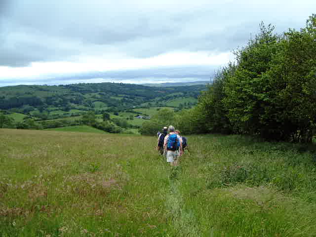
footbridge over the East Onny River before climbing up on to Adstone Hill. It is
a big, steep pull up there but it doesn’t go on too long. The reward is a long
section of easy walking with wonderful views of the rolling Shropshire hills. Or
at least they would have been if the whether had been better. At least the group
had ceased complaining at the wetness of the walk and had started to agree that
it would have been a really nice walk on a good day. We still had to hide in a
barn for lunch. We left the ridge at Wentnor and descended down a steep
path to the road. Then it was road
walking (well, lane walking) to Norbury. Then pick up the track across via
Nurton Farm to pick up the Shropshire Way just south of Linley Hill. We
followed this all the way back. By now the sun had come out and we were treated to some
stunning views, right into mid-Wales with Corndon (an old favourite prominent)
and Heath Mynd (my only unclimbed Marilyn in Shropshire - the access is tricky)
I was the only one who took the short diversion on to a view point by Linley
Hill – it was inspiring. As well as the remants of a Golden Jubilee barbecue.
The others had stopped for a drink; what a treat they missed. There is another section of ridge before the path descends
steeply before the final big climb up to Rock House on the Stiperstones Ridge.
Easy walking back to the cars. I did suggest that we popped up to the
Stiperstones but no one took me up on this.
16 June A really good day which was different for a number of reasons. John Rhodes is also a member of Market Drayton Ramblers and he mentioned last week that they were going to Lake Vernwy. I cadged an invite to go. They are a friendly crowd and made me feel very welcome. I'd never walked in this area before. I'd like to say I knew where we went but I can't work it out on my old 1:50000 map. I know that we didn't see the lake but not a lot else. We started by the river Vyrnwy about 3 miles below the reservoir. This was Pont Llogel where there is good parking. We walked into Llwydiarth and then took the minor road north. I haven't a clue how we got from there to Dolanog, from where we returned to the cars along the river (except for a gratuitous bit of climbing near the end). The route followed Glyndwr's Way and then picked up the Ann Griffith's Trail. She was a hymn writer (probably in Welsh) and she has a memorial chapel at Dolanog. I was able to translate this from an inscription in Welsh, which pleased me no end. The camera batteries were playing up and I didn't get many shots. Here is a selection
Another day out on my own in Wales. A fairly gray day too. I ran into rain as I went through Bala and, whilst this had eased by the time I reached Blaenau Festiniog, the tops were under cloud. I set out with a little foreboding. The walk went out behind the main car park up into the Maen Offeren quarry. The book said that, when you get into the main bowl of the quarry, go to the left of the ruined manager's house through the rhododendron. In fairness it did say the path was a bit over grown. I tried fighting my way through going sharp left without luck. Eventually I plunged into the solid wall of rhododendron with engulfed the path and after a short while found the path. There is then a short climb to the first ruined winding house and then you head onto the moor and see another winding house beyond it. There is a gate and stile just past this. There is then about a mile of unpathed moor to Penamnen. You get your first sighting of it from the first ridge. To my surprise and delight, the top was below the cloud (unlike Manod Mawr, my other objective, which had been visible since reaching the second winding house) The summit is quite shapely. It is a bit of a pull at the end but most disappointingly the cloud came down as I reached the top and I didn't get the best views. The Moelwyns are on the opposite side of the valley. As I left the top the cloud lifted. There is a long ridge leading eastwards. As I was going along the cloud lifted off Manod Mawr too, although the day was still very gray On the top of Foel Fras you come to a fence which is the guide line. Follow this along the edge of a wood and turn right along the first fence that joins it. This leads all the way to the north top of Manod Mawr (it is one of those hills with two tops both of which count as Hewitts). The way is still pretty boggy to begin with but it gets better as it climbs to North Top. The climb is surprisingly gentle. The top is nicely rocky - the platforms make really good seating - and I sopped to take photos all around. The next objective, the true top of Manod Mawr, was clearly visible. The prettiness of the top is sadly something of an illusion. Largely hidden, under a sharp drop, is another slate quarry and you have to cross this to reach the summit. They work on Saturdays and as I had done the climb I had heard sirens followed by blasts. There is a big warning sign as you enter the quarry land saying that the quarry is dangerous. Still they do allow access and I walked down the track into the business area of the quarry before striking of to the left of the lake. You then keep aiming at the top. Again the cloud came down just after I reached the summit and before I took any photos. It had a coldness which suggested that it was going to stay so I didn't hang around. i got back below the cloud and on to the track leading down to Blaenau from the quarry. I'd been following the Nuttalls' route to here. Their descent takes in two disused inclined planes but the first wasn't very accessible (I suspect that there is new quarrying) so I stayed on the track as it went southwards to Llyn Manod. This is a nice steady descent. At the lake I left the path where it turned back on itself along the lake shore. Instead I carried on southwards under the cliff of Manod Mawr. The sun came out and there was a lovely view down the Vale of Festiniog. The path swings right and reaches a lane through cottages before picking up the main road towards the bottom end of Blaenau. 30 June Beryl and I went out on our own and did 9 very flat miles. We parked in Wheaton Aston and walked northwards up the canal towpath. We struck across eastwards over fairly unwalked fields full of large flies to pick up the Staffordshire Way near Whiston. Back along that through Lapley back to the canal and walked back into Wheaton Aston by it. We'd had fine weather but the sky collapsed just after we got back.
|
|